For the second of our two back-to-back walking tours in Tuscany, we were off to the Chianti wine region. Our first tour leader, Ben, drove us back to Pisa airport, along with our companions that were flying out, to meet our second tour leader, Adrienne, who was at the airport meeting her coming week’s crowd. Adrienne merged us with her flying customers and drove us 90 minutes south to our hotel at Castellina in Chianti, the Salivolpi, which a couple of us couldn’t resist calling the Saliva-pol.
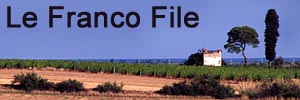
 As we left the autostrada and drove into the Chianti region itself, we were at last greeted by scenery that matched our mental image of Tuscany. Here were the more rounded, vine-covered hills with stark lines of columnar cypress trees, though the hills were more serious than we had expected, I think. The steeply sloping vineyards reminded me somewhat of those in the Beaujolais region of France.
This was Francine’s birthday week and we kicked it off with an unsettling glitch making for disturbed campers. The main problem was the room we were initially given at the Saliva-pol Salivolpi. Our room was right by reception with its unobscured bedroom window opening out directly onto the crunchy gravel car park and the equally crunchy pedestrian route leading to the the hotel’s main entrance. The bathroom window was little better but was, at least, obscured glass. Particularly with the room lights on, this was like living in a noisy fish bowl. Fortunately, the hotel staff jumped though hoops to juggle bookings and move us to another room. My advice would be to reject room #15 at the Saliva-pol Salivolpi.
A contributing difficulty to our unsettled demeanour, which probably wouldn’t affect everyone, was that we had just acclimatized to one set of companions in the best holiday accommodation we’d ever experienced, and had changed both with no intervening gap. I don’t think we’d choose to do two separate tours back-to-back again. A gap would make it feel like a new trip rather than a (dis)continuation.
 Having said that, once the room was sorted out, our new companions were also great and once people got to know each other, we settled into having a very good time. The walking in Chianti was generally shorter and less strenuous than the mountains of the Garfagnana but, with the aforementioned higher-than-expected hills, they still got the heart pumping. Picking ripe figs off the trees beside our trails proved to be a popular source of entertainment. Naturally, as we were approaching harvest, a few of Chianti’s Sangiovese grapes were sampled along the way, too. Francine’s significant birthday lunch was a picnic in a Chianti vineyard, prepared by Adrienne and washed down by a Chianti classico that I’d carted along in my rucksack especially for the occasion. 😉
Between walks, this was a more varied week than the first with a considerable emphasis on culture, including, of course, the local vino of which the Italians are justly proud. Since we were now in a town, we reverted to Explore!’s normal format of no meals included. Instead, evenings were spent in restaurants where it was naturally de rigueur to sample bottles of Chianti classico. Happily, with the exception of one, these Italian restaurants did a lot better than those we experienced the previous week.

 Other aspects of our Italian culture introduction were day trips to nearby Siena and Florence. I’m not a great city fan, being crowded places full of ladies that find passing a shop impossible, and offering such diversions as theatres and art galleries both of which fail to interest me. Fortunately, a couple of other males on the trip were of a similar mind and we distracted each other with the occasional beer to maintain sanity. Of the two, I found Sienna visually more appealing. The most notable thing to me about Florence was the apparently undeveloped water front of the river Arno flowing through it. Curious, I thought. Along with a couple of my male pals, I tried the Boboli gardens which consisted of grass, trees, paths and a couple of completely sterile-looking ponds, though I did find a dragonfly in residence on one of them. Given the complete lack of vegetation, I was very surprised.
 There was one other spot of town culture that I had to endure, although, with San Gimignano being the mid-point of a decent walk, that visit had its saving graces. San Gimignano’s old culture was for the town’s merchants to build tall towers. Building a taller tower was the way the rich of San Gimignano said “up yours” to their not-quite-so-rich neighbours.
There’s a quintessential Italian delicacy that we have thus far completely ignored: gelato [ice cream]. Wandering back from one restaurant in Castellina in Chianti, we came across an ice cream parlour (why does ice cream come from parlours?) open into the late evening. Casual investigation was fatal – the dark chocolate fondant looked irresistible, and so it proved to be. This was the most luxuriously decadent ice cream we had ever tasted. Rumours of other particularly fine ice creams available in Siena led to an on-going experiment, purely scientific, you understand. We just had to sample ice creams on our travels and decide which was the best. Our vote was unanimous, the ice creams from the late night parlour at Castellina in Chianti got our vote. Of course, we had to have another before leaving Chianti to verify our decision. 😉

Happy birthday Francine!


Recent Comments